AI-powered insights from drone images to agronomy decisions — actionable maps, instantly.
Stop guessing. Start recommending. Make every flight count.
Free demo - no credit card required
Use drone & satellite imagery to monitor crop health, detect weeds, analyze stand counts, and manage nutrients.
Optimize breeding, crop protection, and hybrid selection with accurate field trials data.
Accurately count plants on your plantation, nursery, or forest site to manage inventory with confidence.
Use drone-based AI analytics to assess crop damage accurately and secure reliable insurance claims.
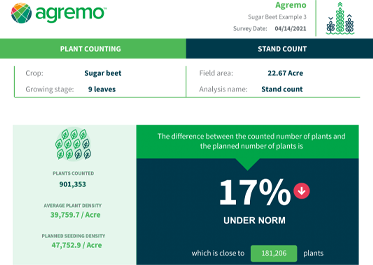
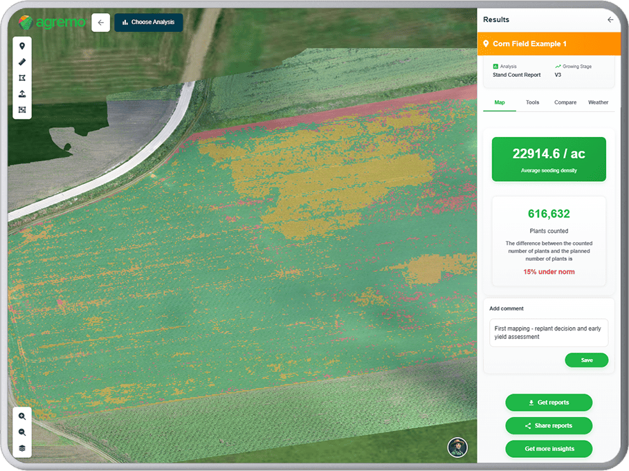
Get precise germination rates, average plant density, and total plant counts to optimize replanting decisions, assess sowing and planting quality, and predict yield potential.
FREE TRIAL
Save up to 75% on herbicides and fertilizers with AI-generated variable rate application maps, maximizing input effi ciency while reducing costs.
FREE TRIAL
Stay ahead of potential issues with weekly health reports and alerts generated from satellite imagery, empowering faster and more effective fi eld scouting.
FREE TRIAL
Generate high-resolution RGB and Multispectral orthomosaic maps. Define field boundaries and mark obstacles with precision. Use measurement tools to calculate distances, areas, and specific coordinates.
FREE TRIAL
Agremo's AI solution turns DJI's drone imagery into actionable insights, and its recipe maps make our AGRAS drone a truly intelligent and precise spraying tool." The integration of the Agremo platform between Agremo and the DJI drone is a turnkey solution for precision agriculture.
The biggest benefit for farmers who use drones and Agremo reports is that they increase their yields, reduce costs or improve their productivity. In the end, all these benefits are lead to extra profits.
Agremo Stand Count analysis shows how successful seeding was and how many plants farmers will be able to harvest. Withal, it can help to apply different sowing standards in different parts of the plot, in order to achieve the highest yields.


