$18M reasons to fight the sugar beet diseases with drones

One of the leading raw materials for the production of manufactured sugar, a well-established crop in the American Midwest, sugar beet, is planted in the early spring and harvested in late September and October. Sugar beet yields tend to be higher in the Far West, but production costs tend to be higher as well.

USDA estimates that 1.12 million acres of sugar beet was planted in 2019.

All beets are grown on contract, and maintaining yield and quality is of the utmost importance in growing the crop successfully and in breaking even however factors such as disease can have a significant impact on yield and sugar content.

The crop is also susceptible to many pests, which can cause direct damage, or introduce viral diseases to the plant. Scouting is an investment in risk management — and catching the early signs of disease infestation can pay for itself.

Disease Detection and Pest Damage analysis is a key aspect of management for producers in all US regions. Chemical pest and disease control on sugar beet in the US can typically cost $85 per acre and represents over 9% of the total production cost per acre for sugar beet.

The most costly diseases for US Sugar beet producers include:

· Cercospora (CLS)

· Beet mild yellowing and

· Ramularioa leaf spot disease

Of these Cercospora is one of the most serious diseases for sugar beet producers in the Mid-West and can lead to losses of up to 40%, and can affect the root tonnage and % sugar in the roots. The loss of sugar from disease can be a major loss of revenue for producers. Every one percent of sugar content equates to 15 pounds of sugar that can be extracted per ton. Across the US this would represent over 60 million additional pounds of sugar per campaign, valued at 18 million dollars.

The disease is devastating once established which is why scouting is so important — you need to get on top of it as soon as it is spotted. In 2018, farmers faced a “perfect storm” of excessive rains and compounded losses due to CLS resistance to fungicides and Cercospora was again reported in Michigan in 2019.

CLS is caused by the airborne fungal pathogen Cercospora beticola. More recently losses of up to $375 per acre have been reported in fields were CLS has not been controlled and the SMSBC (Southern Minnesota Sugar Beet Cooperative) reported in 2016 that their growers lost over $30 million due to CLS.

For an effective treatment, it is vital to timely and correctly identify the disease and the extent of infestation within the crop.

How Does Scouting Help?

Scouting is increasingly important in crop management, in helping farmers improve disease & pest control and lower input costs and losses — technology can help and drones are being used for a whole range of crops including sugar beet.

Young beet seedlings are most vulnerable to stress, scouting for stand establishment and early signs on insect infestation should be carried out in May and early June, scout for root aphids in mid to late September.

A drone is a good helper in spotting plant disease and weeds and getting accurate and useful results. Manual scouting is limited by our visual perception, while the drone scouts every square meter of the field. Time is saved in crop walking, and because you don’t have to walk through the crop there is less disturbance.

Several benefits that drone-based plant disease analyses have compared to traditional measures are:

· Fast and save time and resources;

· Able to cover around 500 acres in less than two hours;

· Accurate — with error rates lower than 2%. And with drones, you are able to analyze every inch of your field;

· Proactive and effective in-season corrective measures.

Read how David was fighting Cercospora with drones & Agremo

How do you get the most out of drone data?

Drones can be an excellent way to collect and gather information on your crop, but do you make the most of the data you collect? How can you use data to get actionable recommendations to benefit your crop? However correct disease identification is vital to effective pest management and that’s why you should only use high-resolution images.

Best practice for drone scouting & Agremo analyses

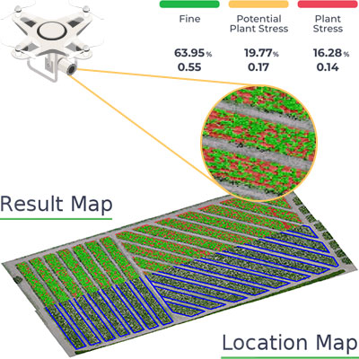
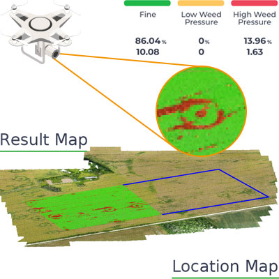
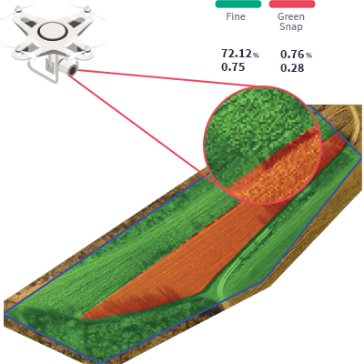
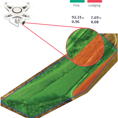
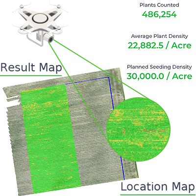
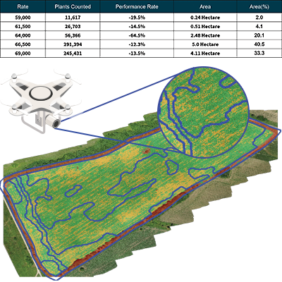
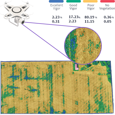
Agremo Disease Detection analysis identifies the percentage and the exact location of plant diseases caused by viruses, fungi or bacteria. Agremo closely examines plants by analyzing various factors, such as changes in the color index, shape or the percentage of missing leaves. Agremo analysis provides you with accurate and actionable insights on your plant’s health, which is why we conduct plant disease analyses in close cooperation with professional agronomists.

Agremo Disease Detection analysis can be used to:

· Identify the precise location and size of problem areas;

· Optimize treatments and preventive measures (fungicide, insecticide, etc.);

· Spot diseases before they affect your current yield goal.

When dealing with sugar beet diseases like Cercospora growers need quick answers to questions like: Is there enough time to apply the treatment? How much of the field is affected and how much fungicide will I have to apply? How much will the treatment cost?

These are all questions that using a drone alongside Agremo Disease Detection analysis can help with. Agremo’s Plant Stress is conducted in close cooperation with professional agronomists to ensure that the data collected is converted into relevant and actionable reports. It is about combining accurate data with human knowledge and experience to provide actionable recommendations on the ground.

Get Your Agremo Stand Count & Weed Detection Report for Free

Create your Agremo account, no credit card needed, Every new user can try it on 20 acres for FREE! Single 20-acre analysis or try both on up to 10 acres.

Share
Try Agremo Analytics

Free - no credit card required

What Our Clients Say About Us

  • Agremo's AI solution turns DJI's drone imagery into actionable insights, and its recipe maps make our AGRAS drone a truly intelligent and precise spraying tool." The integration of the Agremo platform between Agremo and the DJI drone is a turnkey solution for precision agriculture.

    DJI Agriculture

    Smart Farming Team

  • As markets become more defined and customer expectations are increasingly specific, Black Gold believes that we must develop greater awareness of how our crops function. Agremo provides a new window into understanding what is happening in our fields at a more granular level and how to move the needle in the best direction.

    Bryan Bowen

    Director of Agronomy at Black Gold Farms

  • Agremo helps us better understand and adjust to changes throughout the growing season. The flexibility and agility the Agremo team has shown through their platform enable us to adjust and meet changing demands due to weather or pest developments as the season progresses. In addition, the Agremo team consistently listens to feedback to ensure that everything works as described for our specific use cases.

    John Glick

    CIO at Cochranville Ag Service

  • After introducing mapping and crop analysis reports to farmers, they could see their field from another perspective. Agremo is helping us bring essential information to farmers which were impossible to get until recently.

    Ramón Pagán

    Mapping Expert and President @ Caribe Drones // Puerto Rico

  • Agremo’s map is more specific. Competitors break their maps into half-acre grids, but Agremo colors the whole thing exactly how it is. Visually, it’s night and day. A lot of farmers are visual.

    Corey Nohl

    Drone Operator and Farmer @ Above All Aerial // MN, USA

  • With Agremo reports, farmers they can increase productivity, reduce major problems by having early warnings during the early stages of the crops preventing major losses. Bottom line, increase ROI while minimizing losses.

    Miguel Ángel Salgado

    General Manager & Mapping Expert @ Ansar Drone // Mexico

  • The best thing about the plant population reports is the accuracy, which is splendid and it is very important! Great service at eye level with the customer!

    Sune Enevoldsen

    Field Manager and Drone Operator @ Noble Nordmann // Denmark

  • The biggest benefit for farmers who use drones and Agremo reports is that they increase their yields, reduce costs or improve their productivity. In the end, all these benefits are lead to extra profits.

    Ciprian Iorga

    General Manager @ La Orizont // Romania

  • We introduced new farming methods to farmers in Africa, who recognized that Agremo and drones can provide them with quicker, more convenient, efficient and accurate way of gathering decision making information.

    Derrick Annan

    CEO @ Aeroshutter // Ghana

  • With Agremo, we doubled our productivity, and our forestry clients are happy with the Agremo reports necessary for the inventory system as well as a stem map with tree distribution.

    Curt Rogers

    Co-owner @ TimberDrone // USA

  • Of the few vendors who advertised drone imagery analytics, Agremo provided a vastly superior capability. It is extremely important to base any remote sensing assessment in solid ground truth. Agremo clearly excelled over their competitors.

    Konrad Kern

    Image Scientist @ Falcon Aerial Data // USA

  • Agremo Stand Count analysis shows how successful seeding was and how many plants farmers will be able to harvest. Withal, it can help to apply different sowing standards in different parts of the plot, in order to achieve the highest yields.

    Zdravko Hojka

    Agroservice and Product Manager (Maize and Oil Crops), KWS SAAT AG

  • Since we ran our first report with Agremo, both our company and our customers continue to be impressed with the accuracy of the reports compared to our ground truthing. We have leveraged many Agremo reports but find the most value in crop health, weed and stand count analyses. We continue to leverage the Agremo intelligence as a proven way to improve our customers’ bottom line.

    Jeff Buyck

    VP of Precision Ag C&B

    GET A DEMO

    Free demo - no credit card required

    What precision agriculture reports do you need?

    • Plant Stress

      • identify and quantify zones of (potential) stress
      • act timely with the most adequate measures
      • increase yield potential
    • Weed Detection

      • spot weed-infested areas in time
      • take immediate effective in-season corrective measures
      • get precise spraying maps
    • Green Snap Detection

      • identify and classify areas with broken plants in the field
      • locate and quantify the crop damage
    • Lodging Detection

      • detect and classify areas with lodged plants
      • locate and quantify the crop damage
    • Stand Count

      • get the precise number of plants in a specific area
      • evaluate seed quality
      • assess field damages
      • know the zones of potential yield losses
    • VRS Stand Count

      • calculate the percentage under the norm in each zone with the same seeding rate
      • reduce input costs in the low-productivity field areas
      • count plants in the best and the worst zones
    • Plant Vigor

      • get data on the exact location, condition, strength, and lushness of vegetation
      • optimize the usage of inputs, save on them and prevent over-application
    • Waterlogging Detection

      • quickly and accurately locate all potential waterlogged areas in your field
      • reduce the negative effects of waterlogging, regardless of the field size and crop sort
    • Canopy Cover

      • get vital data on vegetation conditions and primary plant productivity
      • get the necessary details regarding the leaf area index (LAI)
      • determine the most optimal LAI for the fruits, vegetables, or cereals


    • Plant Count and Size Analysis

      • Count all plants in the field, such as leafy greens, trees, or orchard tree fruits.
      • Classify them per user-set size parameters, and filter out the counted plants per size.
      • Prepare the harvest operation per yield-ready zones