Agremo’s Field Trials monitoring product helps Product Development Managers, Senior Research Coordinators, and University Researchers improve product performance. It saves valuable time on field analysis, providing accurate, actionable data to continuously enhance product outcomes. Agremo offers reliable insights throughout both the testing phase and the final stage, helping to define product specifications for marketing. By using Agremo, you can add value to your product with data that proves its quality.

Free demo - no credit card required


Yes, you can use the Agremo app and technologies for your trials, whether those are microplots, stripes, or breeding fields. Just let us know what crops are you working on and which phenotypes are you interested in.
So far Agremo has analyzed over 100 crops for our users across the globe. Even though the majority of Ag professionals are still using the RGB, we support multispectral and NIR data. here is no specific analysis which is purely RGB, Multispectral or NIR oriented, as it depends on a specific case we are solving. That is why I would say that we have a problem-specific approach for analysis performed from the “generic” data sources, which contributes to the growing popularity of the Agremo app.
Even though very early stages or quite late stages of the plant development, we can count most of the plants from the moment they are detectable on the map. For example with an excellent map, we can count corn in the V1 phase. Our system employs a combination of different algorithms to provide you with the most accurate plant counts on the market.
Yes, together with the results you will get a result SHP file that you can further use per your needs in 3rd party software or mechanization.
Yes, of course. You can import field boundaries and annotations by importing SHP or KML file, or connecting to MyJohnDeere Operations Center, and importing the boundaries from there. You can use the SHP-KML import option for any kind of boundaries – growers field, trial, or breeding plot.
One of the benefits of the Enterprise level account is that when you require certain customization, we can scope it and let you know whether we can make it happen. Custom analyses are one of the options which we have successfully delivered to our clients. Just let us a challenge you are trying to solve, and we will gladly scope and work with you on delivering the custom analysis.
Yes, you can. Our Professional level and Enterprise level clients can have multiple accounts under their main Umbrella account. The accounts can have different roles and permissions, and allow seamless access and collaboration on your organization account.
If you don’t have internal resources for drone mapping or you don’t want to invest in buying drones, we can do the drone mapping for you by utilizing our drone resources or finding a fit 3rd party drone service provider in our DSP partner network. In addition to that, if you are interested in building up your drone team, we can guide you through that process as well.
Our reports are highly accurate. The AI, machine learning, and computer vision technology backing Agremo app are allowing us to perform highly accurate analyses for the phenomena of interest – counting plants, to identifying different types of damage. The general accuracy of our reports is over 95%, with counting validated on over 98%. Please keep in mind that accuracy is affected by various factors such as map GSD, flight setup and equipment, plant growth stage, state of the field, weather conditions etc.

Agremo's AI solution turns DJI's drone imagery into actionable insights, and its recipe maps make our AGRAS drone a truly intelligent and precise spraying tool." The integration of the Agremo platform between Agremo and the DJI drone is a turnkey solution for precision agriculture.
The biggest benefit for farmers who use drones and Agremo reports is that they increase their yields, reduce costs or improve their productivity. In the end, all these benefits are lead to extra profits.
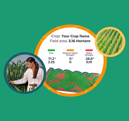
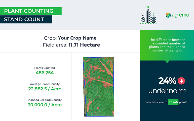
Agremo Stand Count analysis shows how successful seeding was and how many plants farmers will be able to harvest. Withal, it can help to apply different sowing standards in different parts of the plot, in order to achieve the highest yields.
