The greatest challenge a forest professional faces refers to obtaining reliable monitoring data at a reasonable price and within an acceptable time frame. Forest audits take too much time and entail substantial financial investments with little guarantee of the reliability of the results. With Agremo, you can obtain an accurate number of trees, get a highly-precise estimate of the seedling survival rate, and assess potential damage. With our easy, understandable, and effective tree monitoring and auditing software, you can conduct lumber potential which will enable you to make detailed predictions and maintain a solid ROI as a result. Improve forest management processes on multiple levels – analyze the state of the forest more precisely and make informed decisions by requesting a demo of Agremo’s State of the Farm analytics.

Free demo - no credit card required


Agremo can differentiate conifers from hardwood trees but it can focus on analyzing single tree type at the time. If you need for example a separate count of each tree type you will have to make two separate requests.
Currently we don’t have the analysis that can measure tree height.
The greatest challenge in counting seedlings is surrounding vegetation. It has to be smaller than seedlings so the best time to perform this analysis is in the dormant season.
Our reports are highly accurate. The AI, machine learning, and computer vision technology backing Agremo app are allowing us to perform highly accurate analyses for the phenomena of interest – counting plants, to identifying different types of damage. The general accuracy of our reports is over 95%, with counting validated on over 98%. Please keep in mind that accuracy is affected by various factors such as map GSD, flight setup and equipment, plant growth stage, state of the field, weather conditions, etc.
The turnaround time is a maximum of two business days but the average processing time is 24 hours. Subscribed users have higher processing priority which means that we will start processing those maps first.
Yes, we do.

Agremo's AI solution turns DJI's drone imagery into actionable insights, and its recipe maps make our AGRAS drone a truly intelligent and precise spraying tool." The integration of the Agremo platform between Agremo and the DJI drone is a turnkey solution for precision agriculture.
The biggest benefit for farmers who use drones and Agremo reports is that they increase their yields, reduce costs or improve their productivity. In the end, all these benefits are lead to extra profits.
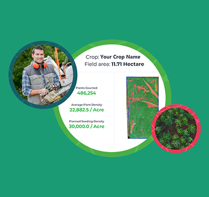
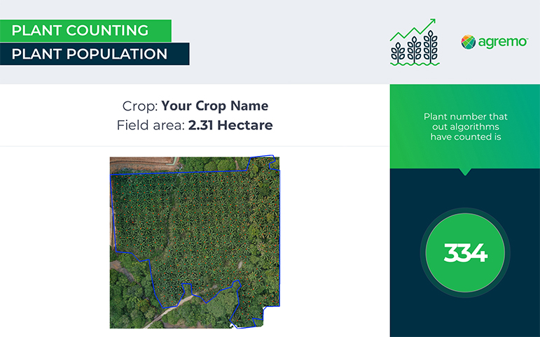
Agremo Stand Count analysis shows how successful seeding was and how many plants farmers will be able to harvest. Withal, it can help to apply different sowing standards in different parts of the plot, in order to achieve the highest yields.

