When a Storm Hits, Every Hour Matters
For insurers, agricultural damage assessment is a race against time.
After a severe storm, thousands of hectares can potentially be affected. Before insurers can evaluate a claim, they must accurately document the extent and location of the damage. And that is not always easy. Fields can be hundreds of hectares in size, damage may vary significantly across the same field, and traditional field inspections can be time-consuming and difficult to standardize. The scale of weather-related losses makes accurate and efficient damage assessment increasingly important.
According to Swiss Re Institute, natural catastrophes generated approximately USD 107 billion in insured losses globally in 2025, with severe convective storms generating more than USD 50 billion in insured losses for the third consecutive year.
Munich Re reported that weather disasters accounted for 97% of global insured natural catastrophe losses in 2025, highlighting just how significant weather-related events are for the insurance industry.
For agricultural insurance, this creates a clear need: faster, more objective and more measurable ways to quantify crop damage. That is where drone imagery and AI-powered analysis can make a difference.
The Challenge: Quantifying Storm Damage Across Hundreds of Hectares
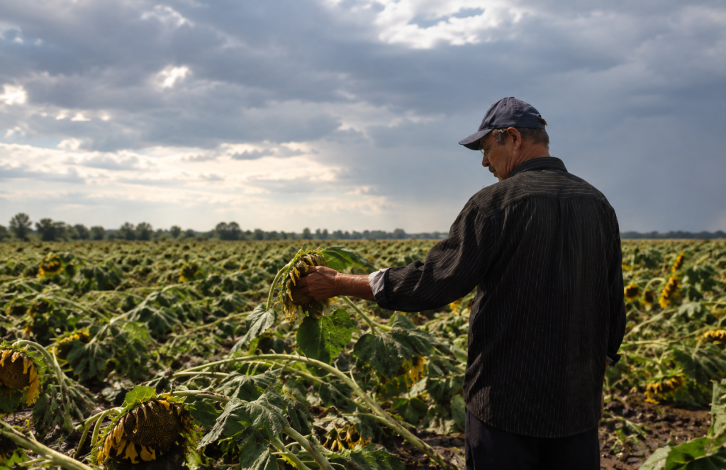
Following a severe storm, a sunflower grower needed to assess the extent of crop damage across multiple fields.
The goal was simple: Map the affected area, quantify the damage and provide reliable evidence that could be shared with the client and used for further assessment. The scale of the operation, however, made manual assessment challenging.
Project at a glance
Client: Paul Dorobantu, Zyntra
Crop: Sunflower
Growth stage: Seed Development & Ripening
Drone: DJI Mavic 3M
Fields: 2 fields (400 ha + 200 ha)
From 600 Hectares to a Precise Damage Assessment
Using a DJI Mavic 3M, the operator mapped approximately 600 hectares across two fields.
The mapping operation covered:
- ~250 km flown
- ~6 hours of mapping
- 1.8 cm/pixel GSD
- 600 ha of sunflower
- 330 ha of quantified lodging damage
The high-resolution imagery provided the foundation for AI-powered crop damage assessment.
Once the imagery was processed, Agremo’s AI Lodging Detection analysis was requested to identify and quantify areas where the sunflower crop had been affected by lodging.
Instead of relying solely on visual inspection, the operator could obtain a map-based assessment of the affected area, including its exact location and calculated area.
The Challenge
Covering such a large area within a single mapping operation also presented a logistical challenge: battery charging time.
To keep the operation moving efficiently, the operator added a second charging hub to the setup. Based on the experience from this project, the operator estimates that this configuration could potentially enable mapping of up to 800 hectares per day, pending further endurance testing.
This highlights the importance of not only having the right drone and mapping workflow, but also an optimized field setup when large-scale agricultural damage needs to be assessed quickly.
The result?
330 hectares of sunflower damage quantified with AI.
This transformed hundreds of hectares of raw drone imagery into structured, measurable information that could be used for further damage assessment and communication with the client.
The Agremo Workflow: From Drone Images to a Damage Report
The workflow was designed to turn field imagery into actionable information in a few clear steps.
1. Upload the drone imagery
The operator first uploaded the row images captured during the drone flight.
2. Stitch the imagery in Agremo
The images were processed using Agremo Stitching, creating a complete high-resolution map of the fields.
3. Request AI Lodging Detection
Once the map was ready, the operator requested Agremo AI Lodging Detection to identify and quantify areas affected by crop lodging.
4. Get a quantified damage map
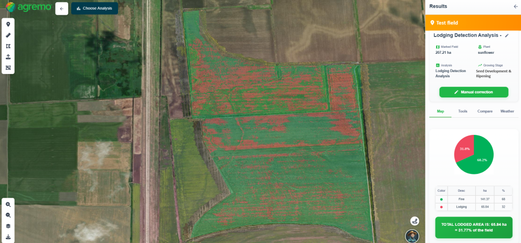
The AI analysis provided a visual representation of the affected areas directly on the field map.
The operator could see:
- Where the damage occurred
- How much area was affected
- The spatial distribution of the damage
- Statistical information about the analyzed field
This is particularly valuable for insurance-related workflows, where knowing that damage occurred is not enough.
From Drone Data to Insurance-Ready Evidence
The value of AI-powered damage detection goes beyond simply identifying damaged crops. Agremo provides the results in a format that can be easily communicated and shared.
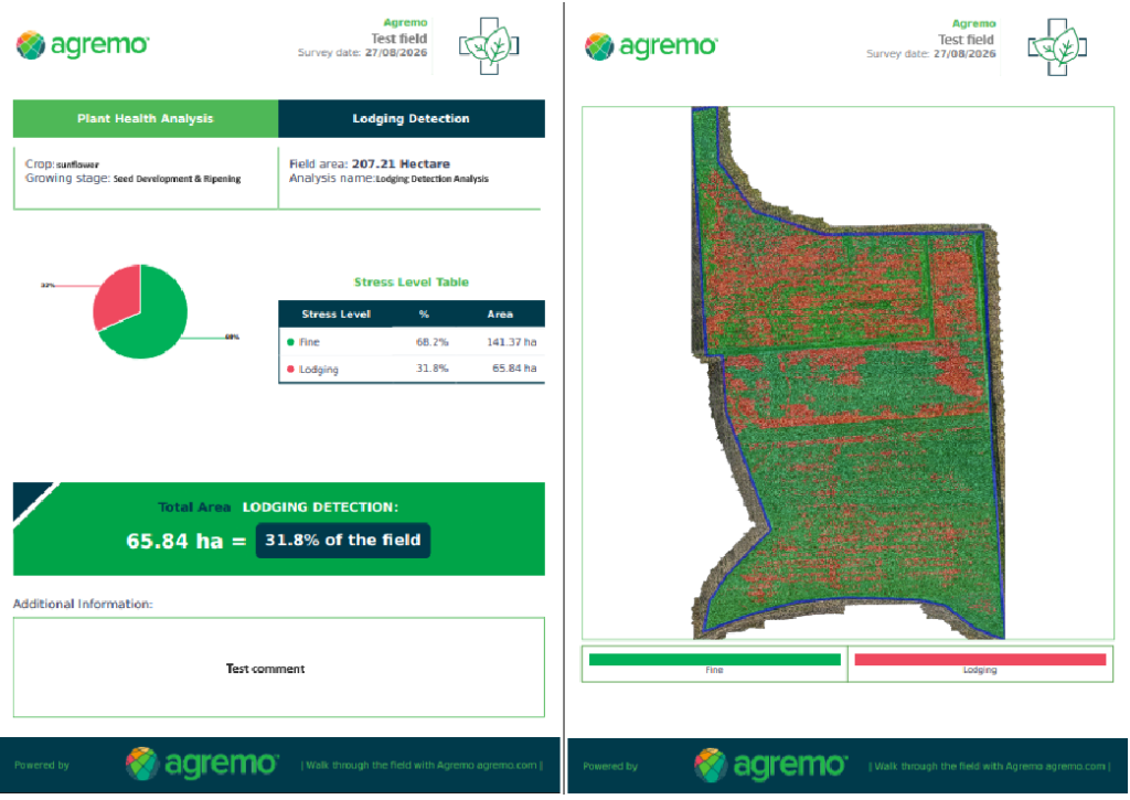
The analysis includes a PDF report containing the key results, statistics and a visual representation of the field.
This creates a clear digital record that can be shared with clients, helping transform drone imagery into structured evidence for the next stage of the claims or assessment process. For insurance institutions and agricultural claims professionals, this can help reduce the dependency on subjective visual estimates and provide a more consistent way to document crop damage.
Why AI-Powered Crop Damage Detection Matters
Storm damage assessment is not simply about finding damaged plants. It is about creating reliable, measurable and geographically precise information that different stakeholders can use.
For insurance companies, this can mean:
- Faster assessment
Large areas can be surveyed without relying exclusively on field-by-field manual inspection. - Objective documentation
Drone imagery provides high-resolution visual evidence, while AI helps quantify the affected area. - Precise localization
Damage can be viewed directly on the field map, showing exactly where affected areas are located. - Standardized reporting
Results can be transformed into structured reports that are easier to share and review. - Scalable operations
The same workflow can be applied across multiple fields and large agricultural areas.
Ultimately, the goal is to move from:
“The storm damaged the field.”
to:
“330 hectares of the 600-hectare area were identified as affected, with the damage precisely located and documented.”
That difference can make the damage assessment process significantly more transparent.
What the Drone Operator Says
“Agremo made it easy to turn hundreds of hectares of drone imagery into clear, quantified damage data. Being able to see exactly where the damage occurred, measure the affected area, and generate a report made it much easier to communicate the results to the client.
When assessing a 600-hectare field in 38°C heat, accurately measuring the affected area through traditional field scouting would be extremely difficult. Having precise data from the field is therefore a real advantage for both the farmer and the insurance company.
I believe this approach could eventually become a standard for agricultural insurance, providing reliable field data from the start of the season and helping insurers assess factors such as poor crop development, waterlogging and elevation differences.”
— Paul Dorobantu, Founder, Zyntra
[email protected]