Best-in-Class Corn Stand Counts with Drone Technology

Best-in-Class Corn Stand Counts with Drone Technology

Evaluating plant emergence is an important early-season management question. Its purpose is to answer the question how many corn seeds have emerged into a healthy plant and whether or not the corn plant population levels are below optimum levels.

A successfully performed stand count will help corn growers get an accurate and thorough picture of the corn seeds that have emerged into healthy plants, and provide insights about areas with potential crop loss. If this information is provided in time, farmers can intervene and even enhance crop yield potential.

Fact is, however, that the common crop counting methods which are currently being used have serious flaws, one of which is that they are mostly estimates with severe error rates.

Besides that, on-the-ground sampling methods are rarely proactive and often fail to mitigate problems in time, leaving farmers with substantial crop loss and budget deficiencies.

Common Plant Counting Methods — Arduous and Unable to Provide Facts

Poor plant emergence can be caused by a variety of things: inadequate seed quality, the wrong seeding rate, an improper planting date or even unfavorable weather conditions.

And in order to spot such deficiencies at an early stage, it’s necessary to do regular stand counts and evaluate the crop population responses effectively.

But common plant counting methods fail to provide unbiased and precise data, as they analyze only small parts of the field. Today, there is a better way to do stand counts: drone-based corn stand analysis.

Farmers who implemented smart farming solutions into their workflow know that the price-performance ratio of today’s drone-technology solutions for agriculture is better than ever before. And while drone operation costs keep decreasing, the associated technological (and financial!) possibilities keep growing.

By contrast, today’s common plant counting methods have changed very little over the past decades in terms of technological efficiency: they all involve a lot of legwork and often include outdated and inaccurate measuring instruments that provide little or no precise data.

Plant Counts Today

One possibility of evaluating corn stands is the 1/1000th acre method. To obtain the number of plants per acre, the corn growers count the number of corn plants in a specific length of row (1/1000th of an acre) and multiply the number by 1000. This is then repeated in different locations in the field.

Similar to this, corn stands can be assessed by taking random samples in the field, or on specific, predetermined locations on the field.

Another way is the so called wheel method, where 150 plants are counted while measuring the distance using a measuring wheel. In order to obtain an estimate of the number of plants per acre, the obtained number is multiplied.

Having in mind how big the limitations and how small the level of accuracy of all these methods is, it seems like a tremendous waste of time and potential to simply stick with such vague ways of determining plant stands. Rather than providing facts, traditional stand count methods offer only estimates and are unable to provide reliable location data.

Especially large-scale farms have difficulty obtaining the precise data they need. Not only do they need to know whether or not they have poor germination rates, they need to know where they are. Common stand counts can’t help with that.

These were the exact points our team of avid drone enthusiasts and precision ag engineers took into account while designing a solution that would allow farmers to see more and simply do better.

“What we came up with is an easy-to-grasp solution that provides tangible results of what is actually happening on your corn field. No special skills required!”, says Milan, the CEO of Agremo.

And with corn season just around the corner, it seems like the perfect time to get a glimpse of how drone-based plant counts can help you work around the limitations of manual stand counts and how you can use drone-based stand counts to ultimately boost plant responses.

Drone-based Plant Counting — at the Top of Smart Crop Management

As opposed to common stand count methods, drone-based stand establishment is designed to provide accurate results which are easily transformed into an action plan with the farmer having to spend less time on the field.

And what’s even more important: you’ll know where the areas with low germination rates are, which allows you to tackle the issue at the very source of the problem.

Thorough and Actionable — Corn Stand Counting with Agremo

Agremo (formerly AgriSens) combines aerial imagery with computer vision and is designed to help farmers maximize every grain of potential. The plant count analysis works on corn as well as on seasonal row crops which are in early growing stages.

This is the biggest advantage of drone-based solutions: farmers are able to adjust ag plans and crop management decisions at the right time and the right place. Smart farming is always prompt and proactive!

How to Boost Corn Yield with Agremo

Working with Agremo is simple:

How to improve farming practices with Agremo

Ask a local drone operator to map your field and upload these images then to a stitching platform such as DroneDeploy. This is requires to turn images into maps, which can then be analyzed. Then go to the Agremo app, upload your 2D map and choose one of the 9 analyses you need — in this case, choose stand count.

Within two business days or less, your report will be ready! You’ll get to know the exact number of plants on your field, as well as valuable information on planting density and planting rate.

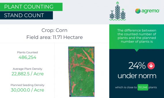
Here’s what one of our users learned about his corn field thanks to Agremo’s stand count report:

The report shows whether the current crop performance is below the optimum level, and if yes, how big the number of potentially lost plants is:

The results of this user enabled the grower to take the necessary measures in time and achieve four-figure savings!

The list of possibilities goes on, as corn is not the only crop type that can be successfully analyzed with drone technology.

Take tomatoes for example: an agricultural consultant from Northern Carolina discovered a more than 20% discrepancy between the expected tomato stands and the actual plant responses thanks to the Agremo plant count analysis.

Want to learn how Agremo can help your business? We’d be happy to tell you more. Get in touch with us or see how working with Agremo looks like!

About Agremo

Agremo (formerly AgriSens) combines high-resolution aerial imagery with state-of-the-art software technology. Our smart farming solutions were developed by a team of passionate developers, drone enthusiasts and successful growers, making it an intuitive and actionable solution for those who are looking to maximize yield potential and reduce risk at the same time.

Try Agremo Analytics

Free - no credit card required

What Our Clients Say About Us

  • Agremo's AI solution turns DJI's drone imagery into actionable insights, and its recipe maps make our AGRAS drone a truly intelligent and precise spraying tool." The integration of the Agremo platform between Agremo and the DJI drone is a turnkey solution for precision agriculture.

    DJI Agriculture

    Smart Farming Team

  • As markets become more defined and customer expectations are increasingly specific, Black Gold believes that we must develop greater awareness of how our crops function. Agremo provides a new window into understanding what is happening in our fields at a more granular level and how to move the needle in the best direction.

    Bryan Bowen

    Director of Agronomy at Black Gold Farms

  • Agremo helps us better understand and adjust to changes throughout the growing season. The flexibility and agility the Agremo team has shown through their platform enable us to adjust and meet changing demands due to weather or pest developments as the season progresses. In addition, the Agremo team consistently listens to feedback to ensure that everything works as described for our specific use cases.

    John Glick

    CIO at Cochranville Ag Service

  • After introducing mapping and crop analysis reports to farmers, they could see their field from another perspective. Agremo is helping us bring essential information to farmers which were impossible to get until recently.

    Ramón Pagán

    Mapping Expert and President @ Caribe Drones // Puerto Rico

  • Agremo’s map is more specific. Competitors break their maps into half-acre grids, but Agremo colors the whole thing exactly how it is. Visually, it’s night and day. A lot of farmers are visual.

    Corey Nohl

    Drone Operator and Farmer @ Above All Aerial // MN, USA

  • With Agremo reports, farmers they can increase productivity, reduce major problems by having early warnings during the early stages of the crops preventing major losses. Bottom line, increase ROI while minimizing losses.

    Miguel Ángel Salgado

    General Manager & Mapping Expert @ Ansar Drone // Mexico

  • The best thing about the plant population reports is the accuracy, which is splendid and it is very important! Great service at eye level with the customer!

    Sune Enevoldsen

    Field Manager and Drone Operator @ Noble Nordmann // Denmark

  • The biggest benefit for farmers who use drones and Agremo reports is that they increase their yields, reduce costs or improve their productivity. In the end, all these benefits are lead to extra profits.

    Ciprian Iorga

    General Manager @ La Orizont // Romania

  • We introduced new farming methods to farmers in Africa, who recognized that Agremo and drones can provide them with quicker, more convenient, efficient and accurate way of gathering decision making information.

    Derrick Annan

    CEO @ Aeroshutter // Ghana

  • With Agremo, we doubled our productivity, and our forestry clients are happy with the Agremo reports necessary for the inventory system as well as a stem map with tree distribution.

    Curt Rogers

    Co-owner @ TimberDrone // USA

  • Of the few vendors who advertised drone imagery analytics, Agremo provided a vastly superior capability. It is extremely important to base any remote sensing assessment in solid ground truth. Agremo clearly excelled over their competitors.

    Konrad Kern

    Image Scientist @ Falcon Aerial Data // USA

  • Agremo Stand Count analysis shows how successful seeding was and how many plants farmers will be able to harvest. Withal, it can help to apply different sowing standards in different parts of the plot, in order to achieve the highest yields.

    Zdravko Hojka

    Agroservice and Product Manager (Maize and Oil Crops), KWS SAAT AG

  • Since we ran our first report with Agremo, both our company and our customers continue to be impressed with the accuracy of the reports compared to our ground truthing. We have leveraged many Agremo reports but find the most value in crop health, weed and stand count analyses. We continue to leverage the Agremo intelligence as a proven way to improve our customers’ bottom line.

    Jeff Buyck

    VP of Precision Ag C&B

    GET A DEMO

    Free demo - no credit card required

    What precision agriculture reports do you need?

    • Weed Detection

      • spot weed-infested areas in time
      • take immediate effective in-season corrective measures
      • get precise spraying maps
    • Green Snap Detection

      • identify and classify areas with broken plants in the field
      • locate and quantify the crop damage
    • Lodging Detection

      • detect and classify areas with lodged plants
      • locate and quantify the crop damage
    • Stand Count

      • get the precise number of plants in a specific area
      • evaluate seed quality
      • assess field damages
      • know the zones of potential yield losses
    • VRS Stand Count

      • calculate the percentage under the norm in each zone with the same seeding rate
      • reduce input costs in the low-productivity field areas
      • count plants in the best and the worst zones
    • Plant Vigor

      • get data on the exact location, condition, strength, and lushness of vegetation
      • optimize the usage of inputs, save on them and prevent over-application
    • Waterlogging Detection

      • quickly and accurately locate all potential waterlogged areas in your field
      • reduce the negative effects of waterlogging, regardless of the field size and crop sort
    • Canopy Cover

      • get vital data on vegetation conditions and primary plant productivity
      • get the necessary details regarding the leaf area index (LAI)
      • determine the most optimal LAI for the fruits, vegetables, or cereals


    • Plant Count and Size Analysis

      • Count all plants in the field, such as leafy greens, trees, or orchard tree fruits.
      • Classify them per user-set size parameters, and filter out the counted plants per size.
      • Prepare the harvest operation per yield-ready zones