
Introduction: Understanding RGB and Multispectral Drone Mapping
Drone technology has become an essential tool in precision agriculture, helping growers, agronomists, and drone service providers collect field data faster and make more informed decisions. As drone adoption continues to grow, one question comes up repeatedly:
Should you use RGB imagery or invest in multispectral drone mapping?
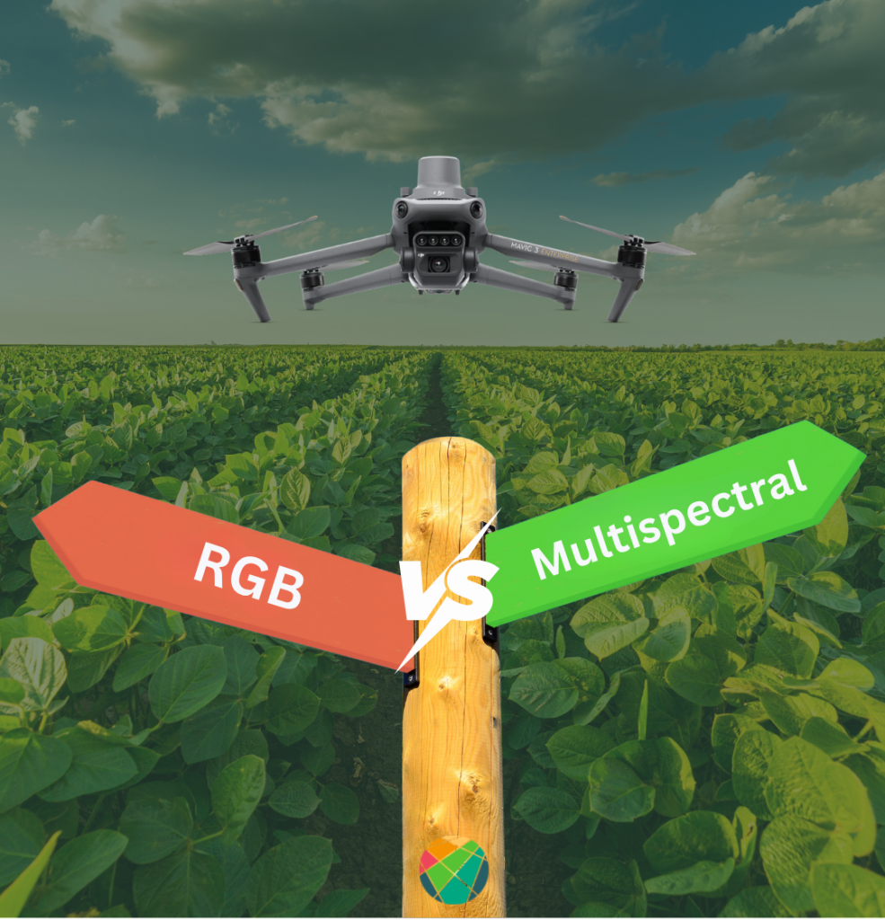
For years, multispectral sensors have been considered the gold standard for advanced crop monitoring because they capture information beyond what the human eye can see. However, recent advances in artificial intelligence and computer vision are changing the way agricultural data is analyzed. Today, high-resolution RGB imagery combined with powerful AI models can deliver insights that were once thought to require multispectral data.
Before comparing the two approaches, let’s take a closer look at how RGB and multispectral cameras work.
What Is RGB Drone Mapping?
RGB cameras capture imagery using three visible light bands:
- Red
- Green
- Blue
Because RGB sensors provide extremely high-resolution imagery, they are widely used for:
- Crop monitoring
- Stand count and emergence analysis
- Weed detection
- Biomass estimation
- Plant health assessment
- Damage detection
- Field scouting
RGB cameras are also more affordable, easier to operate, and generate significantly smaller datasets than multispectral sensors.
What Is Multispectral Drone Mapping?
Multispectral cameras capture additional wavelengths outside the visible spectrum, typically including:
- Green
- Red
- Red Edge
- Near Infrared (NIR)
These additional bands are commonly used to generate vegetation indices such as NDVI and NDRE, which help evaluate plant vigor and crop variability. While multispectral imagery can provide valuable information, it also introduces additional operational complexity, including longer flight times, larger datasets, increased storage requirements, and more demanding processing workflows.
This raises an important question:
Does collecting more data always lead to better agricultural insights?
To answer that question, we conducted a real-world comparison using the DJI Mavic 3 Multispectral.
RGB vs Multispectral: A Real-World Test Using DJI Mavic 3M
To evaluate the practical differences between RGB and multispectral mapping, we performed a field test using the DJI Mavic 3 Multispectral (M3M).
The objective was simple: Compare the operational requirements of collecting RGB imagery only versus collecting both RGB and multispectral data, and determine whether the additional multispectral information provides additional value when processed through Agremo’s AI-powered analytics platform.
Flight Parameters🚁Drone: DJI Mavic 3 Multispectral (M3M)
🌱Field Size: 53.8 ha
📷Resolution (GSD): 2.5 cm/pixel
🚀Flight Speed: 12.7 m/s
📊Front Overlap: 80%
📊Side Overlap: 70%
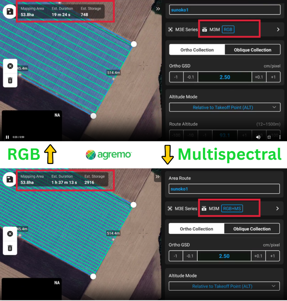
The results were striking.
For the same field, flight speed, overlap settings, and image resolution:
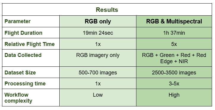
- RGB mapping required only 19 minutes and 24 seconds
- RGB + multispectral mapping required 1 hour and 37 minutes
In other words, collecting multispectral data required approximately five times more flight time than capturing RGB imagery alone.
For drone operators managing multiple fields per day, this difference directly affects productivity, battery consumption, mission planning, and operational costs.
The Hidden Cost of Multispectral Data
When discussing RGB vs Multispectral drone mapping, the conversation often focuses on vegetation indices and spectral bands. What is frequently overlooked is the operational cost of collecting and processing multispectral data.
Compared to RGB imagery, multispectral workflows typically require:
- More flight time
- More battery swaps
- Larger storage capacity
- Longer upload times
- More complex data management
- Additional processing steps
Every multispectral mission produces multiple datasets that must be processed, stored, and analyzed.
As field sizes increase, these requirements grow rapidly, making multispectral operations significantly more resource-intensive than RGB mapping.
More Data Does Not Always Mean Better Insights
One of the most common assumptions in precision agriculture is that more data automatically leads to better decisions. While multispectral cameras capture additional spectral information, the real value lies in the insights generated from the data—not in the amount of data collected. This is where artificial intelligence changes the equation. Modern AI systems can identify patterns that go far beyond traditional vegetation indices by analyzing relationships between plant structure, texture, canopy characteristics, spatial variability, and other visual indicators that are present in RGB imagery.
As a result, the quality of the analysis increasingly depends on the intelligence of the algorithm rather than the number of spectral bands collected.
How Agremo Delivers Advanced Insights from RGB Imagery
At Agremo, we have invested years in developing AI models that extract meaningful agronomic information directly from high-resolution RGB imagery.
While our platform fully supports both RGB and multispectral datasets, our approach goes far beyond traditional vegetation-index analysis. Our algorithms are trained on both RGB and multispectral imagery, allowing us to leverage the strengths of each data source while continuously improving the accuracy of our models.
Rather than relying solely on indices such as NDVI or NDRE, our AI analyzes a broad combination of parameters, including:
- Plant structure
- Canopy characteristics
- Texture patterns
- Spatial relationships
- Field variability
- Vegetation information
- Advanced computer vision features
- Crop-specific growth patterns
This multi-layered approach enables our platform to identify and quantify crop conditions with a high level of accuracy while significantly reducing the dependence on multispectral data collection.
Built on One of the Largest Agricultural Datasets in the Industry
The effectiveness of any AI model depends on the quality and diversity of the data used to train it.
Agremo’s algorithms are continuously trained and improved using a global agricultural database that includes:
- Millions of analyzed acres
- More than 100 crop types
- Diverse climates and growing conditions
- Agricultural operations from around the world
- Both RGB and multispectral datasets
Our machine learning models are continuously refined as new validated datasets become available, allowing them to adapt to different crops, regions, and field conditions while improving accuracy over time.
The Result: RGB and Multispectral Deliver the Same Actionable Insights
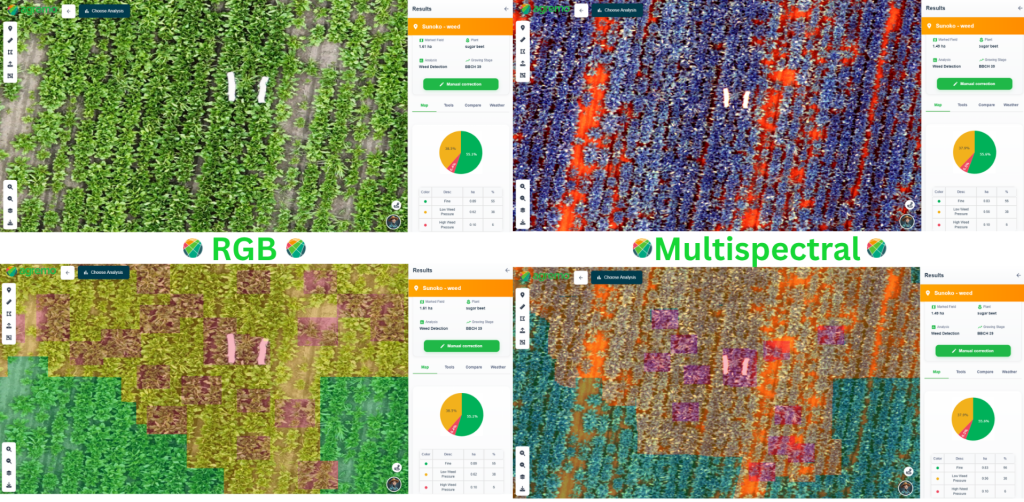
For the vast majority of agricultural use cases supported by Agremo, the end result remains the same whether the analysis is performed using RGB imagery or multispectral data.
Thanks to our AI-driven approach, users can obtain the same actionable insights for applications such as crop monitoring, stand assessment, plant vigor evaluation, weed detection, and field variability analysis without the need to collect additional multispectral bands.
In other words, while multispectral imagery can provide additional spectral information, our algorithms are able to extract the information that matters most for decision-making directly from RGB imagery.
The result is a faster, more efficient workflow that reduces flight time, processing requirements, storage needs, and operational costs—while delivering the same practical value and agronomic insights to the end user.
For many precision agriculture professionals, the question is no longer whether multispectral data is available.
The real question is:
Do you need it?
With modern AI-driven crop analytics, RGB imagery is often all you need to make confident, data-driven decisions in the field.